South West Coast Path Walks
The South West Coast Path is England's longest waymarked long-distance footpath and a National Trail. It stretches for 630 miles (1,014 km), running from Minehead in Somerset, along the coasts of Devon and Cornwall, to Poole Harbour in Dorset. Because it rises and falls with every river mouth, it is also one of the more challenging trails. The total height climbed has been calculated to be 114,931 ft (35,031 m), almost four times the height of Mount Everest.
The path originated as a route for the Coastguard to walk from lighthouse to lighthouse patrolling for smugglers. They needed to be able to look down into every bay and cove: as a result, the path closely hugs the coast providing excellent views but rarely the most direct path between two points. The South West Coast Path is no longer used by the Coastguard but it has been transformed from a practical defence system into a resource for recreational walkers.
There are a number of extremely pictureque circular walks in the local area which take in sections of the South West Coast Path. They vary in length and difficulty, but all revel in the natural beauty of the coastline. Trail maps for seven walks can be viewed and download below.
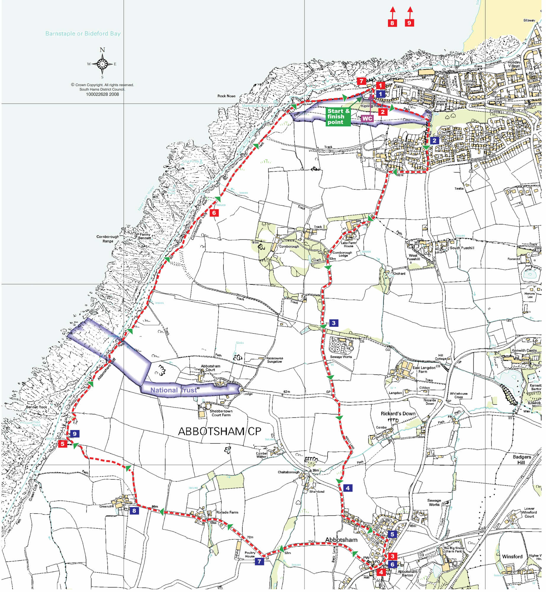
Abbotsham and Westward Ho! - DOWNLOAD PDF
- Start/Finish: Kipling Tors car park, Westward Ho!
- Distance: 5.5 miles (9km) Circular walk: Yes
- Grade: Easy to moderate
- Terrain: Quiet country lanes, public footpath, green lane, and coast path. Fairly even going underfoot, with a few wet or muddy patches in damp weather.
- Obstacles and steep gradients: None
- Accessibility: A shorter Access for All route follows part of this walk along the coast path from Westward Ho!
- Toilets: Public toilets by Kipling Tors car park.
- Parking: Kipling Tors car park. Free
- Other Facilities: Public payphone by church in Abbotsham.
- OS map: Explorer 139 Grid ref: SS 423291
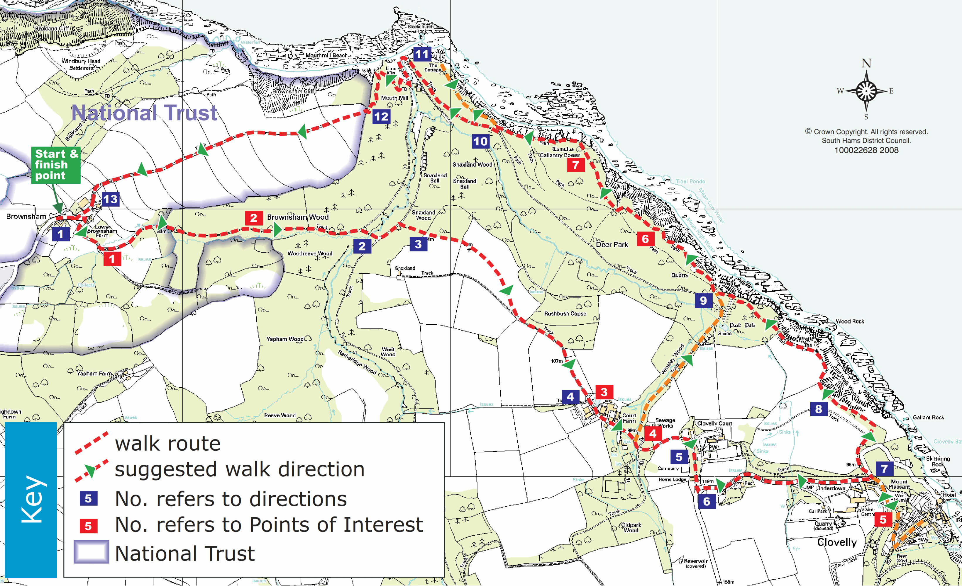
Brownsham & Clovelly - DOWNLOAD PDF
- Start/Finish: Brownsham car park
- Distance: 5.5 miles (9 km)
- Circular walk: Yes Grade: Moderate
- Terrain: Coast path, public rights of way, surfaced road, and green lane. One rocky and uneven stretch and some slippery patches in wet weather.
- Obstacles and steep gradients: 3 flights of steps; 2 stiles; 1 steep ascent;1 steep descent
- Accessibility: Route is unsuitable for wheelchairs or pushchairs
- Toilets: No public toilets on route. Toilets are available in Clovelly, a short detour from main route
- Parking: Brownsham National Trust car park. By donation
- Other Facilities: Public payphone, post office and general stores in Clovelly village, a short detour from main route
- OS map: Explorer 126 Grid ref: SS 285259
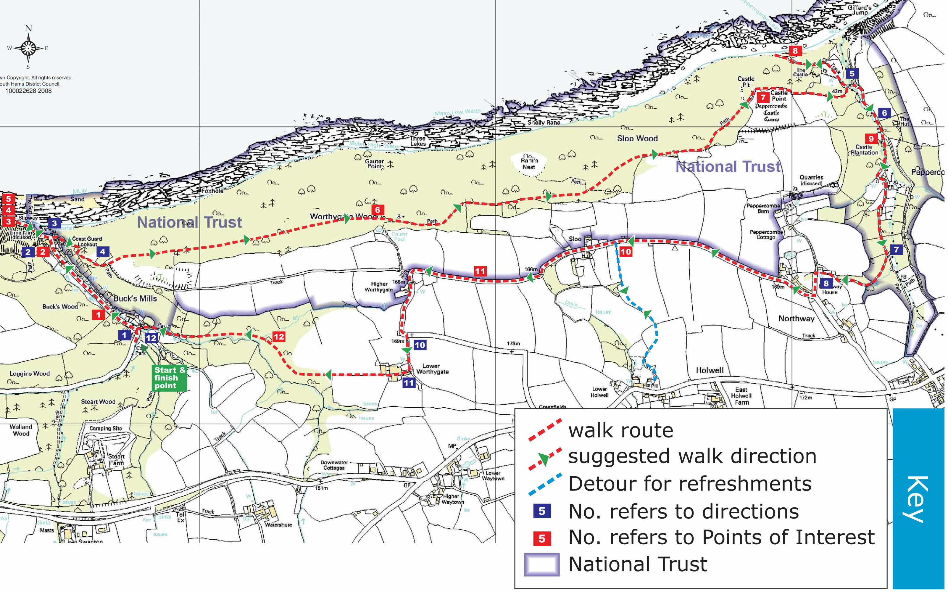
Bucks Mill - DOWNLOAD PDF
- Start/Finish: Bucks Mills car park (7 miles west of Bideford off the A39)
- Distance: 5.5 miles (9.0 km)
- Circular walk: Yes
- Grade: Moderate
- Terrain: Coast path, public rights of way, surfaced road. Mostly reasonable underfoot. Some slippery stretches on coast path in wet weather
- Obstacles and steep gradients: 3 flights of steps; 1 stile; 1 steep climb
- Accessibility: This route is not suitable for wheelchairs or pushchairs
- Toilets: No public toilets on walk route
- Parking: Bucks Mills car park. Free
- Other Facilities: Public payphone in Bucks Mills, to right where walk route turns onto coast path from village street
- OS map: Explorer 126 Grid ref: SS 358232
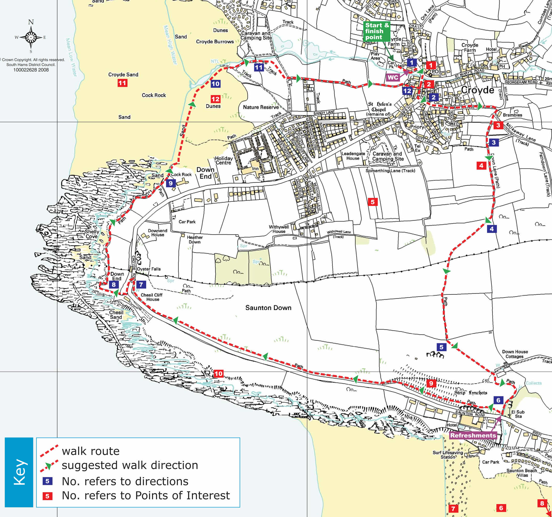
Croyde and Saunton Down - DOWNLOAD PDF
- Start/Finish: Croyde Village Car Park
- Distance: 3.5 miles
- Circular walk: Yes
- Grade: Moderate
- Terrain: Coast path, public footpath, surfaced road. Fairly even underfoot, with a few slippery stretches.
- Obstacles and steep gradients: 8 flights of steps; 7 stiles
- Accessibility: This route is not suitable for wheelchairs or pushchairs
- Toilets: Public toilets at entrance to car park.
- Parking: Croyde Village Car Park. Pay and Display
- Other Facilities: Public payphone at entrance to car park on left. Village stores and post offi ce opposite car park entrance.
- OS map: Explorer 139 Grid ref: SS 444392
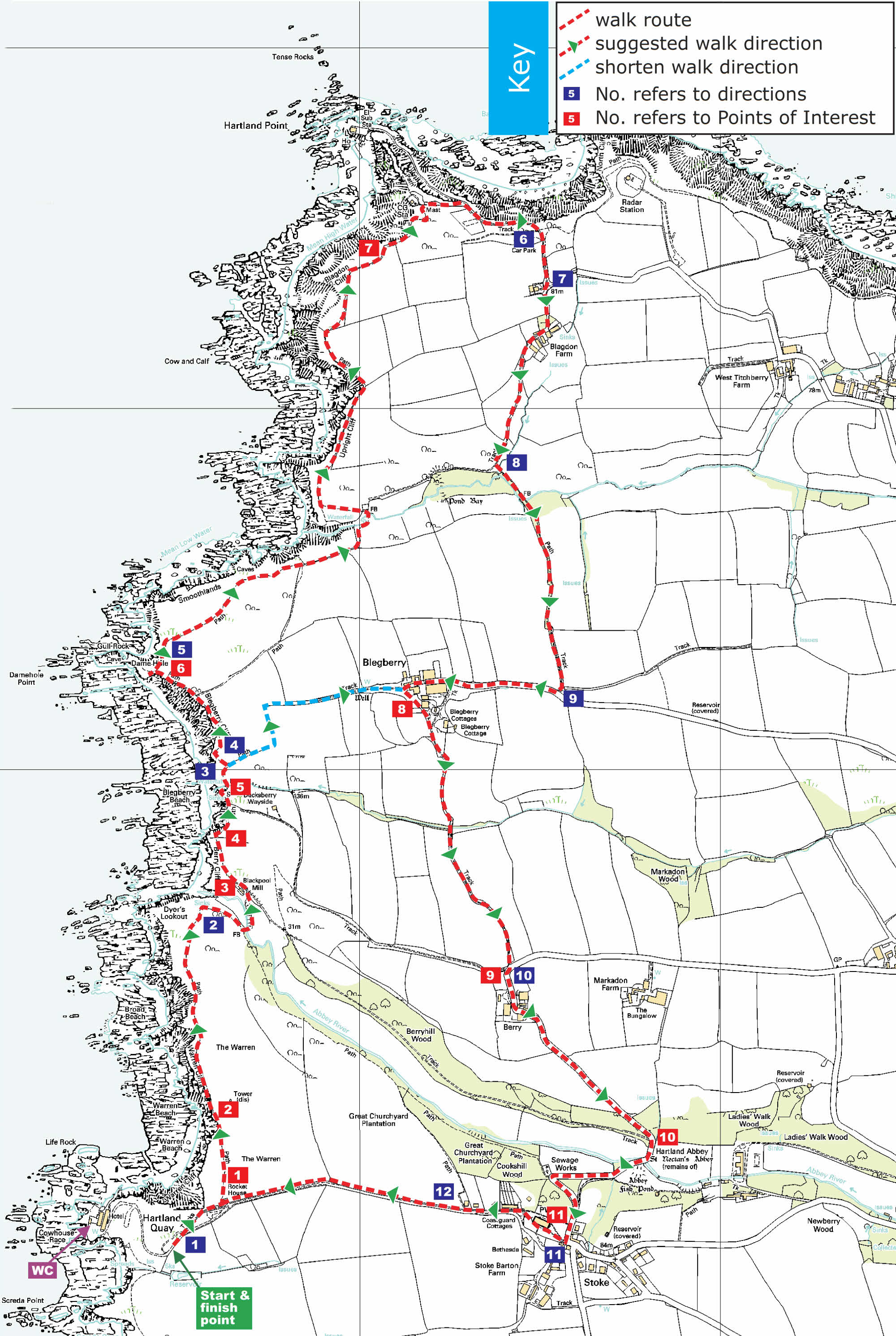
Hartland - DOWNLOAD PDF
- Start/Finish: Hartland Quay car park (3 miles west of Hartland)
- Distance: 6 miles (9.5 km); shorter route 3.5 miles (5.5 km)
- Circular walk: Yes
- Grade: Short route: moderate to strenuous. Full route: strenuous
- Terrain: Coast path, public rights of way, surfaced road. Mostly reasonable underfoot. Some tricky footing on coast path
- Obstacles and steep gradients: 6 fl ights of steps; 4 stiles; 5 steep ascents; 3 steep descents
- Accessibility: This route is not suitable for wheelchairs or pushchairs
- Toilets: Public toilets by Hartland Quay Hotel; also in Stoke, by church
- Parking: Hartland Quay car park
- Other Facilities: Hartland Quay Hotel, refreshment kiosk at Hartland Point
- OS map: Explorer 126 Grid ref: SS 224247
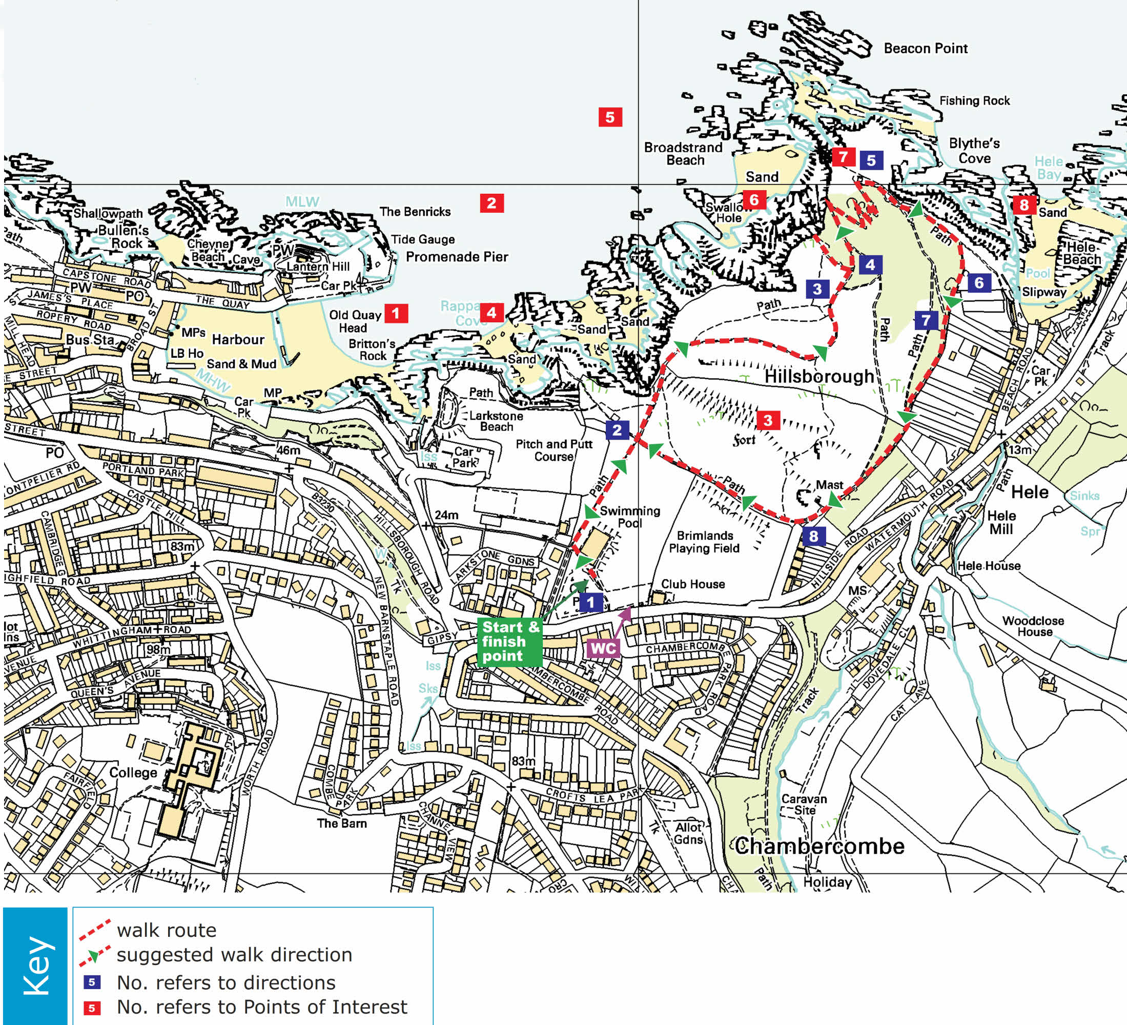
Hillsborough - DOWNLOAD PDF
- Start/Finish: Hillsborough Car Park, Hillsborough Rd, Ilfracombe
- Distance: 1.5 miles (2.5km)
- Circular walk: Yes Grade: Moderate
- Terrain: Coast path and public footpath. Some rocky, uneven, slippery and muddy patches
- Obstacles and steep gradients: 10 flights of steps; 1 steep descent
- Accessibility: Route is unsuitable for wheelchairs or pushchairs
- Toilets: Public toilets at Hillsborough Car Park; also at Hele Beach
- Parking: Hillsborough Car Park, Hillsborough Rd, Ilfracombe. Pay and Display
- Other Facilities: Public payphone 150m down Hillsborough road from car park, on left.
- OS map: Explorer 139 Grid ref: SS 529473
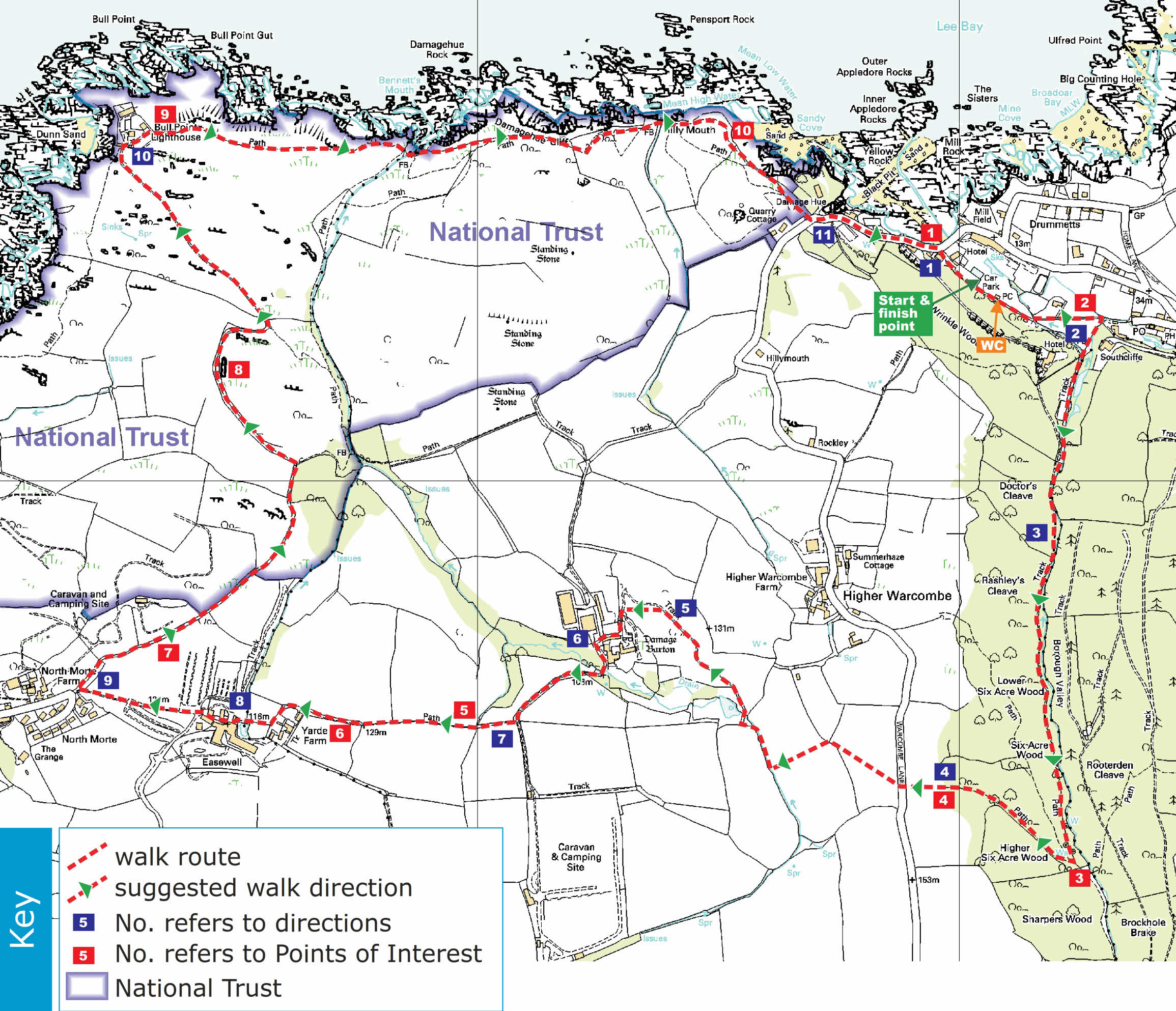
Lee Valley and Bull Point - DOWNLOAD PDF
- Start/Finish: Lee Cove car park
- Distance: 5 miles (8 km)
- Circular walk: Yes
- Grade: Moderate to Strenuous
- Terrain: Coast path and public footpath. Some rocky, uneven, slippery and muddy patches
- Obstacles and steep gradients: 6 flights of steps; 14 stiles (4 can be avoided); 3 steep ascents; 2 steep descents
- Accessibility: This route is unsuitable for wheelchairs or pushchairs
- Toilets: Public toilets 75m up footpath along route from car park
- Parking: Lee Cove Car Park. Pay and Display/honesty box
- Other Facilities: Public payphone on right, 700m back up through Lee village from Cove car park
- OS map: Explorer 139 Grid ref: SS 480464
Useful Links
- South West Coast Path (https://www.southwestcoastpath.org.uk/)
- North Devon Coast Areas of Outstanding Natural Beauty (https://www.northdevon-aonb.org.uk/)
